On the night of June 28 into the early hours of June 29, 2025, residents across Minnesota experienced a dramatic and terrifying reminder of nature's power. A widespread outbreak of tornado warnings, severe thunderstorm alerts, and reports of radar-indicated rotations triggered panic, swift action, and a cascade of community responses across the Twin Cities metro and surrounding counties. While damage assessments are still ongoing, the events of that night will be etched into memory for thousands.
A Timeline of Turmoil
Evening Hours: The Calm Before the Storm
As dusk settled over Minnesota, few could have predicted the chaos to come. Early weather forecasts did suggest the possibility of isolated thunderstorms, but the rapid intensification of cells after sunset caught many off-guard. By 8:30 PM CDT, the National Weather Service (NWS) began issuing severe thunderstorm warnings in western and central counties, and by 9:00 PM, the radar showed strong rotation in several areas.
8:46 PM: Tornado Near Canby
The first major alarm came with a confirmed tornado near Canby in Yellow Medicine County. Labeled a "particularly dangerous situation," this tornado was accompanied by half-dollar-sized hail and high wind gusts. Emergency sirens blared, and many residents sought shelter in basements and interior rooms.
10:00 PM to Midnight: Warnings Spread
Over the next two hours, tornado warnings began to spread eastward. Counties like Renville, Kandiyohi, Lac qui Parle, and Chippewa went under high alert as rotation signatures were picked up on Doppler radar. Though many tornadoes remained radar-indicated, the potential for destruction prompted emergency services to activate contingency plans.
Midnight Madness: The Twin Cities Threat
12:15 AM CDT: Scott, Carver, and Sibley Counties
As the storm system pushed into the metro area, tornado warnings were issued for Scott, Carver, and Sibley Counties. Residents in Shakopee, Chaska, and Chanhassen were advised to take immediate cover. Social media was flooded with images of blackened skies, eerie green lightning, and sirens piercing the quiet night.
12:35 AM CDT: Twin Cities Under Siege
Perhaps the most alarming moment came just after 12:30 AM, when a tornado warning blanketed much of the Twin Cities metro, including Minneapolis, St. Paul, Edina, Eagan, Bloomington, Richfield, Apple Valley, and even areas near MSP airport. Radar-indicated rotation prompted an urgent alert: "TAKE SHELTER NOW."
Despite no confirmed touchdowns in the cities, the widespread alert caused confusion, fear, and a scramble for safety. Families gathered in basements, and apartment dwellers sought refuge in inner stairwells. Metro Transit services were temporarily halted.
Community Response and Preparedness
Emergency Services on High Alert
The Minnesota Department of Public Safety coordinated with local emergency managers to deploy extra crews overnight. Utility companies braced for damage as winds toppled trees and downed power lines in several locations, especially near Highway 7 in the southwest metro.
Hospitals & Public Buildings
Several public buildings were converted into temporary shelters, though most residents remained in their homes. Hospitals initiated emergency protocols to prepare for possible influxes of storm-related injuries. Fortunately, as of early morning June 29, there were no confirmed fatalities or major injuries.
Damage and Aftermath
Visual Impact
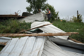
Early images from Chanhassen and Eden Prairie show fallen trees, minor roof damage, and cars dented by hail. In rural counties like Renville and Lac qui Parle, barns and farm structures bore the brunt of the storms, with preliminary reports indicating structural collapses and lost livestock.
Power Outages
More than 40,000 residents experienced power outages at the storm's peak, according to Xcel Energy. As of noon on June 29, crews were still working to restore services in suburban and rural areas.
Psychological Toll
For many, the night served as a grim reminder of how quickly nature can turn hostile. Social media became a platform for both real-time updates and emotional expressions:
"We had 3 kids and our dog in the bathroom for 30 minutes. Terrifying. Thank God we're safe."
Weather Terminology: Watch vs. Warning
This event also highlighted the importance of public understanding around weather alerts:
Tornado Watch: Conditions are favorable for tornadoes. Stay alert.
Tornado Warning: A tornado has been sighted or indicated by radar. Take shelter immediately.
Confusion between the two often leads to unnecessary panic or dangerous hesitation. Local officials plan to increase awareness campaigns this summer.
Looking Ahead: Recovery & Reflection
While Minnesota has experienced tornado outbreaks before, the June 28–29 event was notable for its urban impact and the sheer number of warnings issued within such a short timeframe. As recovery continues, meteorologists are studying the atmospheric conditions that led to the outbreak, hoping to refine future predictions.
Local governments are considering bolstering alert systems, especially for vulnerable populations like seniors and non-English-speaking residents. Weather radio sales and emergency app downloads have surged in the last 24 hours.
Final Thoughts
Though terrifying, the events of that stormy night revealed a community ready to respond, support each other, and rebuild. From emergency responders to everyday citizens checking in on neighbors, Minnesota demonstrated what resilience looks like in the face of nature's fury.
As cleanup continues and skies clear, one truth remains: preparedness saves lives. And while the storms have passed, the lessons remain vivid. Let this be a call not just for better forecasting, but for stronger communities united by care, caution, and courage.
Stay safe, Minnesota.


.jpg)


